


 |
 |
Leave the Mule at Home
The least-known scenic skyway in the East
by Barry Henderson
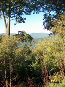
Cherohala is not a Cherokee Indian term for spectacular. But it could have been. The Cherohala Skyway makes an understatement of its own designation as a scenic highway. Drive it, and it’s a mile-high high, an adventure that will take your breath away and hold it in a marathon parade of vistas.
The road, completed less than eight years ago and still undertouted as a tourist attraction, winds from Tellico Plains, Tenn., to Robbinsville, N. C. It ambles along a dramatic route through the Cherokee and Nantahala National Forests, hence the moniker, a simple contraction of the forests’ names.
The skyway hugs the contours of the Tellico River basin and the Smoky Mountain ridges along its 50 miles so carefully and unobtrusively you can imagine at times that you’re riding a mule along that rugged passage 200 years ago.
Dotted with overlooks, pull-offs, hiking trails, and the occasional restroom, it has no commercial intrusions, no billboards, not even cell phone service. Get gas before you go. There’s nothing along the skyway except the pavement and guardrails, the rustic picnic tables and informational signs and plaques to mar the magical appeal of those hazy peaks and hollows. And, especially on weekdays, almost no traffic. A recent run from the Tennessee side and back was easy, fun and instructive. On a Friday afternoon, motorcycles outnumbered cars about 12 to 1.
The route’s appeal to motorcyclists is understandable. Its lazy curves, dips and rises make it the high-arched Dragon’s Back to the switchy, twitchy, exhilaratingly treacherous Dragon’s Tail on U.S. 129. The Dragon dives back toward Maryville and Knoxville from the skyway’s eastern end with an 11-mile stretch below Deal’s Gap that features the 318 curves that gave it its nickname.
Up on the skyway, the bikers, like the motorists, are mostly cruising at their leisure. There’s the occasional sports-biking pair or small group crotch-rocketing at peril to themselves and others, but it’s not the detraction it is on 129, where you don’t see the bikers until they’re nearly on top of you, and you hope that doesn’t become a literal description.
The first five skyway miles follow the rippling white water of the Tellico River, and, though that may not be what you expected, it’s among the prettiest sections, one where trout-fishing outplays tourism.
The next nine miles is a curvy climb up through mixed hardwoods, pine and poplar, to Indian Boundary, with its lake and campground. Soon after that, you break out near the ridgetops, with long views on either side.
At the 24th mile, you leave Monroe County, Tenn. and enter Graham County, N.C., at Beech Gap. You’ve risen to 4,600 feet above sea level by then, and you keep climbing onto a five-mile run above 5,000 feet, with a 5,390-foot pinnacle and 100-mile views. A 15-mile descent follows, some of it at a 9 percent grade (Don’t try this in your ’73 Dodge Monaco with the leaky master cylinder and mushy brake pedal!) to the entrance to the Joyce Kilmer Memorial Forest.
You can’t miss it. The site of that entrance is marred by a cluster of unsightly billboards, huckstering upcoming commercial distractions farther on.
Next up is picturesque Lake Santeetlah, with two nearby mountain lodges—the Blue Boar Inn and Snowbird Mountain Lodge, both of which require reservations. The first gas pumps are 47 miles out of Tellico Plains at a convenience store with a trading post theme that is just outside Robbinsville.
Past the city limit, it’s a couple more miles to the nondescript business district, which has a cafe or two, a pizzeria and the Phillips Motel and Restaurant, where the countrified buffet is a passable option if you forgot to pack a picnic. Unless you really need to eat, rent a video, take a rest in a tanning salon or contract for some fill dirt, give Robbinsville a pass. For those who are unable to resist the souvenir impulse, an overgrown and shabby single-wide mobile home at the west end of town advertises American Indian craft items of the sort created by the Philippine Band of the Cherokee.
You will have driven an hour-and-a-half to two hours, depending on how many photo stops you made. Turn around and head back into Tennessee the same way, leaving the Deal’s Gap Dragon route to those with strong constitutions and/or the need for speed and roller-coaster thrills. You won’t see anything along 129 to rival the splendor of the skyway. The return trip is just as superbly eye-catching, as you are seeing everything from the opposite angle.
A fine restaurant, the Bistro By The River, awaits you at the edge of Tellico Plains, which retains some of its charm despite its growing devotion to antiques and the tourist trade.
Getting to the skyway from Knoxville is an easy, rolling hour’s drive down to Madisonville on U.S. 411 and another 20 minutes on Tenn. 68 to Tellico Plains and the river section.
All in all it’s a beautiful daytrip, and the leaves are just turning. The sourwoods are already deep crimson. You won’t fight the bumper-to-bumper traffic of the Great Smoky Mountains National Park to partake of the fall color. And, it’s a good bet you’ll be back in the spring.

October 7, 2004 • Vol. 14, No. 41
© 2004 Metro Pulse
|
|