|
Comment
on this story
|
|

A view of seven states from Lookout Mountain...or not
by Barry Henderson
So, is it possible in all actuality to See Seven States from Rock City atop Lookout Mountain, Tennessee?
Well, the answer is: Maybe, maybe not...it depends on a lot of factors, known and unknown. More on that question later. As they say, half the fun is getting there.
"See Rock City" is more than just the slogan on barn roofs, birdhouses, belt buckles, and hot-air balloons on which it's been writ, large and small, seemingly ad infinitum, over the past seven decades.
It's been very nearly a mantra for denizens of the American South and the millions of visitors drawn to this corner of the Sunbelt through the years.
It all began in the depths of the Great Depression, on May 21, 1932, when Garnet and Frieda Carter opened their "Rock City Gardens" to the public and were stumped, briefly, about how to advertise the maze of pathways amid massive sandstone outcroppings that they had developed as a tourist attraction. They had the location right, just off intersecting U.S. Highways 11, 41, and 27 in Chattanooga. It was a natural. Getting motorists to turn off there was the trick.
But Garnet had a vision. In the mid-1930s, nearly desperate for attention, he gave a friend named Clark Byers a pickup truck, a supply of black and white paint, and a mission. Byers was to paint "See Rock City" on as many barns along all highways—and not a few byways—leading toward Chattanooga as he could. Securing barn owners' permission proved not all that difficult. Free paint in a pitiful economy was too tempting to turn down.
Forty-odd years and 900-odd barns later, the "See Rock City" command and its frequent accompaniment, "See 7 States," had been emblazoned in white on black from Michigan to Florida and from Virginia to Texas.
Well before the barn-painting binge withered away, Carter had a plan to provide mailboxes, constructed by Byers, that bore the same message. But the U.S. Postal Service intervened. At that, he took his model box, cut holes in it, added perch-pegs, and declared it a birdhouse. He gave away or sold thousands of those, and they appeared indoors and out at truck stops, bus-route diners, motor courts, and flea markets almost everywhere in the United States and a few spots in Canada. You may still see a faded barn here and there, and a lot of birdhouses bearing the ad. The ashtrays, doormats, and bath towels that went along for the ride are pretty much collectors' items nowadays, except in Rock City's own amply arrayed souvenir shops. The new souvenir items may be reproductions, they may be campy up near the max, but still they sell to tourists.
"See Seven States," though, had a special appeal then, in the infancy of air travel that remains a source of curiosity today.
So it was, that right here in the placid offices of Metro Pulse, a normally naive member of the paper's usually boosterish staff, uttered what turned out to be a challenge. "Nobody can see seven states from up there. That's a myth!"
Immediately a crack team, consisting of one bewildered but intrepid investigative reporter and his eagle-eyed, only infrequently drooling editor, was set on the trail of the legend.
Here's how it all turned out. The reporter arrived at Rock City in a steady drizzle on a Saturday afternoon, when nothing could be seen from the brow of Lookout Mountain at the 1,700-foot elevation but drizzle and clouds, above and below and beyond.
By Sunday morning, the rain had ebbed to a mist, and the clouds were being described by the local weather guessers as "high, scattered, variable," a virtual synopsis of the state of journalism at that place, date, and time.
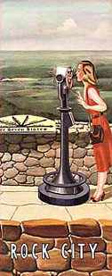
Plopping down his 12 bucks at the entrance, the newsy pocketed his nickel in change precisely at 11:32 a.m. Binoculars, camera, and compass at the ready, he trod gamely up the garden path, sidled through the narrow "Needle's Eye" and, holding his breath, tip-toed across the "Swing-Along" suspension bridge toward his quarry, hardly glancing at the wondrous rock formations, the penned-up imported deer, or the occasional, friendly- looking ceramic elf who held out a helping lantern.
At last, the focal point was reached: Lover's Leap—the legendary ledge where a brave named Sautee was supposedly tossed to his death and his true love Nacoochee, a Cherokee princess, was alleged to have thrown herself behind him, in a tribal feud of some sort, perhaps mimicking Shakespeare's best-known romantic tragedy.
There, amid the 14 pay-telescopes (a few seconds for a quarter), was the demi-dial that pointed the way to each of the five states besides Georgia, which one is standing in, and Tennessee, directly below and to the north, that can purportedly be seen on a clear day through heavy lenses.
After carefully taking exact approximate compass readings through an engineers' lensatic instrument, peering out onto the mist-shrouded horizon through heavy lenses, and popping a few photos, the reporter made his way back. He braved such hazards as the grotesquely decorated, ultra-violet-lit Fairyland Caverns, the gauchely similar Mother Goose Village, and the outrageously, inevitably stereotypical elfin Moonshine Still, clearing the gate and exiting the parking lot in a cold sweat to bring you this first-hand report.
At the very next opportunity, a couple of anxious days later, the University of Tennessee's director of cartographic services, Will Fontanez, took those compass readings and applied them to a computerized map, an azimuthal equidistant projection like the ones aviators use to get precise headings and distances.
Other than being pretty far off on their distances, the Rock City sight-lines were more or less accurate. "Mt. Pinnacle," the Kentucky-Virginia point described as 120 miles to the northeast, is probably "The Pinnacle," a peak on the border of the two states nearest Tennessee that is more like 150 to 155 miles away. The nearest point in the "Smoky Mountains" that Rock City points to as North Carolina is more like 70 miles distant, rather than the 50 miles listed on the Lover's Leap dial, and the very nearest point in South Carolina is between 125 and 130 miles away, not the dial's listed 80 miles. Alabama, 25 miles due south, is dead on.
But can you "see" that far, from one elevated point to another similar summit?
"It's possible," says Fontanez, a cartographer and lecturer at the university, "I've never been there, but theoretically...."
He defers to his colleague at the UT Department of Geography, Prof. Charles Aiken, who has taught there since 1969 and whose students' current courses include [the geography of] the American South, is not sure, either.
"I've been up there once, or possibly twice," says Aiken. "I've stood at the spot and looked. I daresay 60 years ago that you could see seven states from there.
"TVA didn't have any coal-fired plants then. We didn't have that many motor vehicles. There were no Interstates. I suspect air pollution effectively prevents that now," Aiken says.
That may be the case, but at least Chattanooga, once one of the nation's most polluted cities in terms of its industries' output of smoke, dust and chemicals into the atmosphere, has been cleaned up to a level where where the city brags that its air is now among the least polluted, right at the foot of Lookout Mountain's vaunted vantage point.
Aiken says he knows of no scholarly survey, no proof scientifically speaking, that the Rock City claims are true.
"I never thought it significant," Aiken says, adding that it seems particularly insignificant today, when an airline passenger can see many more than seven states at a time from some locations 40,000 feet in the air.
Not significant? A boast that lined thousands of miles of roadway and festooned the crowns of countless ballcaps?
Will we never know?
Maybe, maybe not. It depends....

September 26, 2002 * Vol. 12, No. 39
© 2002 Metro Pulse
|